Street, Road and Highway Projects
Re: Street, Road and Highway Projects
Yes, you can get survey information for exact ROW widths off the Hennepin County Property Maps. That's not the same thing as street widths, though.
-
mattaudio
- Stone Arch Bridge
- Posts: 7760
- Joined: June 19th, 2012, 2:04 pm
- Location: NORI: NOrth of RIchfield
Re: Street, Road and Highway Projects
I've been meaning to ask... for probably 6 months, there's been work in the median of MN-77 immediately north and south of 494 near MOA. I haven't been able to find a project description online. Anyone aware of what's going on?
-
HiawathaGuy
- Wells Fargo Center
- Posts: 1636
- Joined: June 4th, 2012, 12:03 pm
Re: Street, Road and Highway Projects
Just bridge work: http://www.dot.state.mn.us/metro/projec ... index.htmlI've been meaning to ask... for probably 6 months, there's been work in the median of MN-77 immediately north and south of 494 near MOA. I haven't been able to find a project description online. Anyone aware of what's going on?
-
mattaudio
- Stone Arch Bridge
- Posts: 7760
- Joined: June 19th, 2012, 2:04 pm
- Location: NORI: NOrth of RIchfield
Re: Street, Road and Highway Projects
If anyone wants to speak out against $1.5 million in 8-80 funds being wasted on making Lexington/Randolph more hostile to non-motorists, here are the public meetings:
Randolph - Feb 4, 6 PM, Highland Community Center
Mac-Groveland - Feb 23, 6:30 PM, Edgcumbe Rec Center
Highland - Feb 10, 7 PM, Highland Community Center
Randolph - Feb 4, 6 PM, Highland Community Center
Mac-Groveland - Feb 23, 6:30 PM, Edgcumbe Rec Center
Highland - Feb 10, 7 PM, Highland Community Center
-
Anondson
- IDS Center
- Posts: 4665
- Joined: July 21st, 2013, 8:57 pm
- Location: Where West Minneapolis Once Was
Re: Street, Road and Highway Projects
The roundabouts are coming, the roundabouts are coming!
http://www.startribune.com/local/west/2 ... y#continue
http://www.startribune.com/local/west/2 ... y#continue
Re: Street, Road and Highway Projects
And outstate MN thinks they don't get any road money spent on them...
That's great, though. They put a bunch in last summer near Madison Ave and Hwy 22 in Mankato, and the whole area works much better now.
That's great, though. They put a bunch in last summer near Madison Ave and Hwy 22 in Mankato, and the whole area works much better now.
Joey Senkyr
[email protected]
[email protected]
-
Anondson
- IDS Center
- Posts: 4665
- Joined: July 21st, 2013, 8:57 pm
- Location: Where West Minneapolis Once Was
Re: Street, Road and Highway Projects
I like reading that there were a few states that have a "roundabout-first" law, that roundabouts must be the first choice and localities must justify something else to prove they won't work. I like that idea.
-
RailBaronYarr
- Capella Tower
- Posts: 2625
- Joined: September 16th, 2012, 4:31 pm
Re: Street, Road and Highway Projects
I love the bit at the end, where a real-life former MnDOT employee weighs in on them:
I know things are changing, but this is the guy who was on a team to help the implementation of roundabouts. I'm not saying they're great in every single situation, but for god's sake, this was a person management felt was a good fit to help that project along in an efficient manner with the best outcomes? What are his thoughts on cycling/walking infrastructure? Transit? There's a huge entrenched culture at our state/local DOTs that reflects (supports?) public perception, and that's really unfortunate.One of them is Jerry Flategraff, a regular at the American Legion post bar a block away on Portland Av. Ironically, Flategraff is a former MnDOT employee who helped create the standards for roundabout signs — a job he called “a bear.”
“Roundabouts should be in Europe, not the U.S.!” Flategraff exclaimed. “Left turn, right turn! That’s it!”
-
LRV Op Dude

- Union Depot
- Posts: 328
- Joined: July 7th, 2012, 10:30 am
- Contact:
Re: Street, Road and Highway Projects
When I drive in a roundabout I just want to go around and around.
Blog: Old-Twin Cities Transit New-Twin Cities Transit
You Tube: Old, New
AKA: Bus Driver Dude
You Tube: Old, New
AKA: Bus Driver Dude
Re: Street, Road and Highway Projects
This my friends is how sprawl happens, one project at a time.
http://www.twincities.com/localnews/ci_ ... -uncertain
*Incognito mode for free viewing.
http://www.twincities.com/localnews/ci_ ... -uncertain
*Incognito mode for free viewing.

Re: Street, Road and Highway Projects
That's such a cute mid century rambler. :/
-
twincitizen
- Moderator
- Posts: 6383
- Joined: May 31st, 2012, 7:27 pm
- Location: Standish-Ericsson
Re: Street, Road and Highway Projects
Taking bids for the project: http://finance-commerce.com/2015/02/min ... placement/In other news, designs have been finalized- http://www.journalmpls.com/news-feed/lo ... y-approvalThe Saint Anthony Parkway Bridge (over Northtown Yard) project has a nice website. Unusually nice and modern for an infrastructure project, I might add.
http://stapbridge.com/
No one made an offer on the current bridge, which the city was trying to sell.
Re: Street, Road and Highway Projects
Test closure of 29th Ave at the Midtown Greenway in Seward. http://content.govdelivery.com/attachme ... oSheet.pdf
"Minneapolis Public Works is exploring a test closure of 29th Ave S at the Midtown Greenway. This will help inform planning work that seeks to improve conditions for walking and biking around Seward Montessori School and along the Midtown Greenway. Currently, the majority of vehicles traveling along 29th Ave S appear to be cutting through Seward Neighborhood between Franklin Ave and Lake Street. The neighborhood and Ward 2 Council Office is very supportive of reducing the amount of cut-through traffic and heavy trucks traveling along 29th Ave S. This is classified as a local street, not a truck route or MSA street. However, two MSA streets exist two blocks to the east and west, 31st Ave S and 27th Ave S, respectively. Public Works will take traffic counts along 29th Ave S, 31st Ave S, and 27th Ave S during the test to analyze how traffic is affected by the test closure. Emergency vehicles, bicycles, and pedestrians would retain access through the test closure. Emergency vehicles could circumvent the barricades and drive over flexible posts when necessary (see attached info sheet, page 2).
Additionally, there are currently five at-grade crossings of the Midtown Greenway between Hiawatha and West River Parkway. The test closure will temporarily eliminate one of these conflict points for Greenway cyclists.
The test closure would begin in late spring and would run roughly 6-8 weeks. The barricades would be removed after this test is complete."
-
mattaudio
- Stone Arch Bridge
- Posts: 7760
- Joined: June 19th, 2012, 2:04 pm
- Location: NORI: NOrth of RIchfield
Re: Street, Road and Highway Projects
Hopefully there are some objective test measurements in addition to public feedback. I've seen a few tests where the only test result is feedback to the city, which is usually overwhelmingly negative (people hate change). An example was the temporary 4-way stop at 28th Ave and 42nd St.
-
twincitizen
- Moderator
- Posts: 6383
- Joined: May 31st, 2012, 7:27 pm
- Location: Standish-Ericsson
Re: Street, Road and Highway Projects
I know what you're saying, and you're right that if public feedback is the only metric, well...you already know what you're gonna get. But to be fair, 28th Ave / 42nd St was not an official "test", was it? I thought it was just road construction that resulted in a temporary 4-way stop. The plan all along was to rebuild with a replacement signal, correct? Kinda hard to stop that PW train after it's already left the station (layouts approved, bids, etc.)
-
mattaudio
- Stone Arch Bridge
- Posts: 7760
- Joined: June 19th, 2012, 2:04 pm
- Location: NORI: NOrth of RIchfield
Re: Street, Road and Highway Projects
They actually did another test after the new stoplights were in, complete with PR and signs noting it was a test. Did not go over well.
-
twincitizen
- Moderator
- Posts: 6383
- Joined: May 31st, 2012, 7:27 pm
- Location: Standish-Ericsson
Re: Street, Road and Highway Projects
God knows what thread we previously discussed this project in, but the city recently completed a total reconstruction of all the streets around Riverside Plaza, including 6th St, 15th Ave, and 4th St - dubbed "Riverside extension.". As part of that project, the little stub of 16th Ave was converted to a non-motorized street, between 6th Street and the Blue Line tracks, as a secondary and more direct connection to the southern end of the LRT platform.
Total curb fail for bikes & ADA though...or is it?
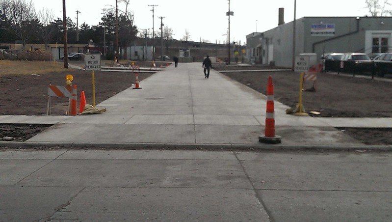
IMAG1322 by twincitizen, on Flickr
Here are the layouts from the whole project, if you're interested: http://www.ci.minneapolis.mn.us/www/gro ... 110639.pdf
You can see in the plans they proposed to ban parking (for about two car lengths) directly across the street from this connection. I don't know why you'd do that unless the intention was to establish a mid-block crossing directly to Riverside Plaza (which is a great idea BTW).
How the hell does this crossing not have a single ADA access point?
Total curb fail for bikes & ADA though...or is it?
IMAG1322 by twincitizen, on Flickr
Here are the layouts from the whole project, if you're interested: http://www.ci.minneapolis.mn.us/www/gro ... 110639.pdf
You can see in the plans they proposed to ban parking (for about two car lengths) directly across the street from this connection. I don't know why you'd do that unless the intention was to establish a mid-block crossing directly to Riverside Plaza (which is a great idea BTW).
How the hell does this crossing not have a single ADA access point?
-
grant1simons2
- IDS Center
- Posts: 4371
- Joined: February 8th, 2014, 11:33 pm
- Location: Marcy-Holmes
Re: Street, Road and Highway Projects
Get a hammer and a chisel
-
Anondson
- IDS Center
- Posts: 4665
- Joined: July 21st, 2013, 8:57 pm
- Location: Where West Minneapolis Once Was
Re: Street, Road and Highway Projects
"Why does infrastructure cost so much in the United States? We don't know yet."
http://www.realclearpolicy.com/blog/201 ... _1249.html
http://www.realclearpolicy.com/blog/201 ... _1249.html
-
twincitizen
- Moderator
- Posts: 6383
- Joined: May 31st, 2012, 7:27 pm
- Location: Standish-Ericsson
Re: Street, Road and Highway Projects
MNDOT 2015 metro district projects: http://www.dot.state.mn.us/construction ... ojects.pdf
EDIT: Hennepin County's workload here: http://www.hennepin.us/media/construction
EDIT: Hennepin County's workload here: http://www.hennepin.us/media/construction
Who is online
Users browsing this forum: No registered users and 178 guests