I know it's still their property and all, but what is BNSF's actual justification for still using the tracks in this area? I mean, the tracks don't go anywhere, and haven't for how long now? Are they just using it for railcar storage? Surely that can be done in the actual railyard/balloon to the east.
I don't see any reason why they couldn't abandon everything west of roughly Bierman or where the track goes under 5th Street. It goes down to a single track there and everything west of that point is just railcar storage/staging.
U of M Bike Trail
-
twincitizen
- Moderator
- Posts: 6383
- Joined: May 31st, 2012, 7:27 pm
- Location: Standish-Ericsson
Re: U of M Bike Trail
They unload coal immediately adjacent to Bridge #9.
-
orangevening
- Nicollet Mall
- Posts: 137
- Joined: June 18th, 2013, 12:18 pm
Re: U of M Bike Trail
I don't get why the U can't put alittle ramp on those stairs. There's a bike lane that leads to those stairs. Bridge 9 would see a lot more trafficIts a good way to get downtown but pointless for connecting to west bank since you have to down 19th ave which has construction right now,take west river parkway and up a huge hill or up the stairs by the anderson library.
-
TheUrbanGopher
- Nicollet Mall
- Posts: 190
- Joined: December 3rd, 2012, 7:03 pm
Re: U of M Bike Trail
I believe BNSF also sees it as valuable real estate and is portraying the ugly combination of semi-attempted property advertising and expecting a top dollar for it. If I remember, that was a problem with the City and the U when they originally developed the bike trail. It was supposed to go closer to the rails than it actually is.
Here is an old article talking about the pitfalls of the project 3 years ago: http://www.mndaily.com/2010/06/23/u-m-b ... ore-delays
Here is an old article talking about the pitfalls of the project 3 years ago: http://www.mndaily.com/2010/06/23/u-m-b ... ore-delays
Re: U of M Bike Trail
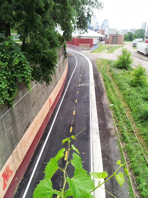
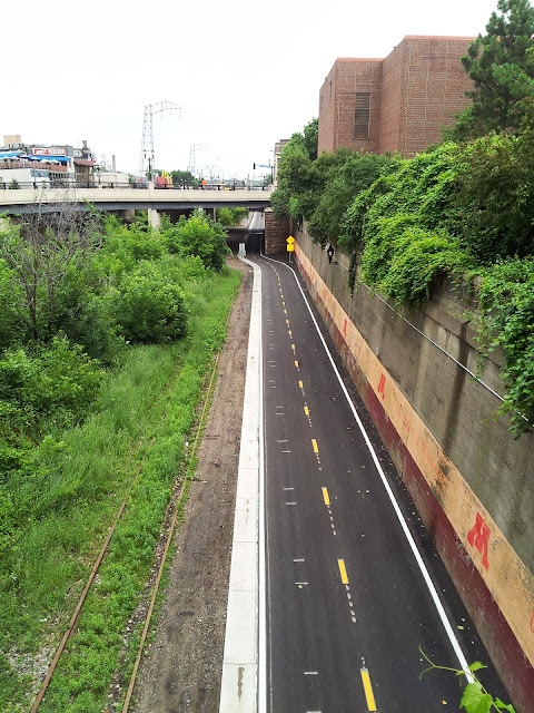
So, I was only scheduled for a short run today so I figured I'd use it to check out the new U of M trail. I'd been wondering how they would route it, and it looks to me like they actually avoided the railroad ROW altogether by hugging it right up against the University and cutting in west of the new biomedical district. Probably the most sensible choice, but I'd rather hoped the trail would run all the way past the biomedical district back on the railroad ROW before cutting down to the transitway just east of the stadium. I suspect the railroad's uncooperativeness is the reason for this.
It's a nice trail; I used to run down here all the time before BNSF finally got me to stop, so I know the area pretty well. I'd been wondering how they would handle the problem of the building access back there, and it seems that they've chosen to simply make the trail serve double duty as the road for those access points. Not ideal, certainly, but given that very few vehicles ever go back there (there were four or five official University vehicles parked between the buildings and the trail today, and nobody driving) it should work out just fine.
To put it in perspective, here's my GPS track: http://connect.garmin.com/activity/341481668. It's just shy of a mile from the river to the Lillehei building, where this new trail segment ends. Obviously, it would be a tidy cut over to the transitway to get on to the St. Paul campus. The truly "new" section - the part back in the railroad area - is a little over a half mile.
You're doing it wrong, look at my GPS track for the right way to do it. The stairs are only if you go around the back way; follow 19th up to Humphrey and cut in to the plaza there.Its a good way to get downtown but pointless for connecting to west bank since you have to down 19th ave which has construction right now,take west river parkway and up a huge hill or up the stairs by the anderson library.
Re: U of M Bike Trail
You're doing it wrong, look at my GPS track for the right way to do it. The stairs are only if you go around the back way; follow 19th up to Humphrey and cut in to the plaza there.Its a good way to get downtown but pointless for connecting to west bank since you have to down 19th ave which has construction right now,take west river parkway and up a huge hill or up the stairs by the anderson library.
yeah thats what i normally do but there was construction when i last took it. i was hoping that they would somehow make a seamless connection to willey.
Re: U of M Bike Trail
That's true, the construction isn't too obtrusive when running but it might be rough on a bike. In general the link between the river and the West Bank is suboptimal, but it's not really bad and it's likely quicker than going through the main part of campus if you're trying to get from the West Bank to the biomedical district or St. Paul. Though it does look like it's slightly farther, I think it's quicker.
Re: U of M Bike Trail
Agreed that its not that bad of a connection, perhaps an example where the U isn't ideally integrated into the surrounding infrastructure. I've always wondered if there will be development on the open block north of the anderson library.
-
orangevening
- Nicollet Mall
- Posts: 137
- Joined: June 18th, 2013, 12:18 pm
Re: U of M Bike Trail
Looking at the old raised RR bed at west end of the bridge, which I assume will become the proposed bluff street trail (that's what the tunnel in the 35w bridge is for) I wonder how they are going to integrate the 2 trails- a little bridge?
Re: U of M Bike Trail
Yeah, I've been curious about that. There's also a former single-track corridor that runs at-grade right between the embankment and the residential tower. It'd probably make the most sense to just remove the embankment entirely, unless everyone gets convinced that an LRT or streetcar connection is going to happen here.

Anyway, here are some shots near the other end of the bridge. Right at the trailhead:
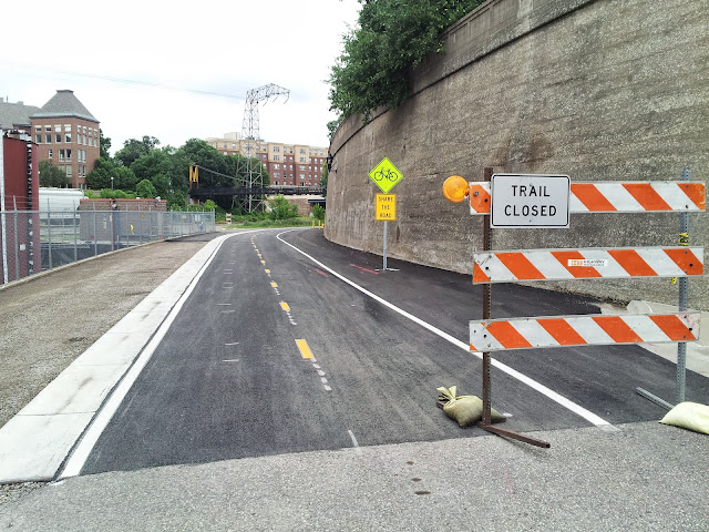
From the "M" ped-bridge over the tracks in both directions:
Anyway, here are some shots near the other end of the bridge. Right at the trailhead:
From the "M" ped-bridge over the tracks in both directions:
Mike Hicks
https://hizeph400.blogspot.com/
https://hizeph400.blogspot.com/
-
mattaudio
- Stone Arch Bridge
- Posts: 7760
- Joined: June 19th, 2012, 2:04 pm
- Location: NORI: NOrth of RIchfield
Re: U of M Bike Trail
How about a heavy rail connection between the NP#9 bridge and a 6th Street bi-level transit tunnel downtown, allowing for commuter and intercity trains to through-route Downtown Minneapolis?unless everyone gets convinced that an LRT or streetcar connection is going to happen here.
Re: U of M Bike Trail
How about a heavy rail connection between the NP#9 bridge and a 6th Street bi-level transit tunnel downtown, allowing for commuter and intercity trains to through-route Downtown Minneapolis?
As long as we make provisions to transfer to the Zeppelin mooring station I've envisioned atop the Wells Fargo tower.
-
TheUrbanGopher
- Nicollet Mall
- Posts: 190
- Joined: December 3rd, 2012, 7:03 pm
Re: U of M Bike Trail
Also relatable is the Bluff Street Park extension that orangevening mentioned. This will (finally!!!) connect downtown to the U of M without having to traverse any interstates, ditches, LRT trains or stairs near Mondale Hall. Ways & Means Committee approved this a couple weeks ago.
http://www.ci.minneapolis.mn.us/www/gro ... 109886.pdf
http://www.ci.minneapolis.mn.us/www/gro ... 109886.pdf
-
twincitizen
- Moderator
- Posts: 6383
- Joined: May 31st, 2012, 7:27 pm
- Location: Standish-Ericsson
Re: U of M Bike Trail
From the Comp Plan of 2009:Agreed that its not that bad of a connection, perhaps an example where the U isn't ideally integrated into the surrounding infrastructure. I've always wondered if there will be development on the open block north of the anderson library.
West Bank Recommendations
␣ Purposeful removal of Anderson Hall will be considered subject to analysis of interim space availability, environmental and economic impacts, and the potential views it will give the West Bank campus to the Mississippi River corridor.
␣ The Social Sciences tower will be upgraded for more efficient use by academic units.
␣ Other potential long term development sites on the West Bank include the Washington Avenue Corridor east of 19th Avenue, the northern recreational fields, the parking lots north of Mondale Hall, and on Riverside Avenue east of 20th Avenue.
␣ The extensive paved plazas of the West Bank will be redesigned to reduce impervious surfaces, improve stormwater treatment, and create a greener pedestrian environment.
So maybe, but not for a long time. In the meantime can we please connect the dead-end bike lanes to that parking lot in a meaningful and safe way that doesn't involve a mandatory dismount, carrying one's bike down the stairs and then riding on the sidewalk to access city streets? I can't tell you how often I wanted to commit a crime and remove that guard rail thing between the sets of stairs...that incline is probably just a hair too steep for bikes to handle it safely though.

Re: U of M Bike Trail
The idea of this is stolen; I couldn't find the original on the Minnesota memes page...
Nick Magrino
[email protected]
[email protected]
Re: U of M Bike Trail
As I said earlier, take 19th around to Humphrey - accessing the upper plaza is maybe a tenth of a mile longer going that way but there isn't the parking lot and stairs. It's true, there's some construction up there which makes it suboptimal right now, but that will be done soon.I can't tell you how often I wanted to commit a crime and remove that guard rail thing between the sets of stairs...that incline is probably just a hair too steep for bikes to handle it safely though.
-
exiled_antipodean
- Landmark Center
- Posts: 286
- Joined: December 3rd, 2012, 8:20 am
Re: U of M Bike Trail
Guess I'm lucky, I've only been stopped by the BNSF police once. The new trail still has "trail not open" signs up, perhaps because the lampposts don't have bulbs in them yet. Will be interesting to see if they keep this trail plowed, I suspect they will because of the dual use by university vehicles. Once the tunnel under 35W to 2nd St opens up this trail will complete a very nice connection between the U, Saint Paul campus, and downtown. It's a bit longer than the shortest route, but it's a pleasant ride or run. If they can get some trees up in the bit between the two parking lots near the biomedical district that would be nice.
-
orangevening
- Nicollet Mall
- Posts: 137
- Joined: June 18th, 2013, 12:18 pm
Re: U of M Bike Trail
It's just dumb to have bike lanes that end at stairs. First time at the U 15 years ago I totally thought there *was* a ramp there (shoot there is one 40 feet away going in the other direction) . Luckly I had a nice mountain bike and made it upright, but I've seen other bikers big it thinking the same thing. I didn't think about when I went to the Q&A happy hour w/ Steve Sanders (umm bike coordinator)- with the new trail it makes sense to fix that dangerous spot. It makes a nice connection to Willey/Belgen from St. Paul CampusAs I said earlier, take 19th around to Humphrey - accessing the upper plaza is maybe a tenth of a mile longer going that way but there isn't the parking lot and stairs. It's true, there's some construction up there which makes it suboptimal right now, but that will be done soon.I can't tell you how often I wanted to commit a crime and remove that guard rail thing between the sets of stairs...that incline is probably just a hair too steep for bikes to handle it safely though.
Re: U of M Bike Trail
walked the new trail saturday. it's very slick and a nice connection to the transitway. that whole area with the new research buildings is coming along nicely. once bluff street trail is completed will be even better. these trails make you want to get on your bike.
having lived in a warm weather city for a few years with laughable bike infrastructure we are just leaps and bounds ahead.
having lived in a warm weather city for a few years with laughable bike infrastructure we are just leaps and bounds ahead.
Re: U of M Bike Trail
Any idea when the U of M Bikeway will officially open? I may or may not have taken a pre-opening tour the other day and it looked pretty much good to go.
I don't honestly see this trail getting that much use. It's super slick, and I will use it as I work in the Alumni Center and have to go to the West Bank Office building, but otherwise it kind of seems to be mostly novel. Am I missing some major use cases?
Moving to the other points, there are many, many paths on the U of M campus that really end horribly. It is an poor place to bike, despite the pure volume of people riding there. Off hand, I can think of a handful of places that are truly embarrassing given the campus is pretty much the number one bike volume spot on in the #1/#2 bike city in the nation.
1.) No dedicated infrastructure connecting w/b East River Road. I take this one every day, so it's personally frustrating having to jump across traffic from the trail to get to campus. (http://goo.gl/maps/gOqzn)
2.) The disappearing bike lanes on University/4th. They disappear at the points you actually need them. Through Dinkytown, crossing the freeway bridge and entering NE. I have learned to take 2nd or the new 5th street bikeway but many others still rely on these lanes day-to-day. (http://goo.gl/maps/jp9Bz)
3.) Scholars walk has "banned" bikes, no there is basically no navigable connection through campus. There is a route which again drops bike lanes in the middle, but it's confusing for new comers. Seems like a speed limit through campus would have been a better alternative, as many folks still bike it. ("legal" alternative roughly http://goo.gl/maps/B8mvj)
4.) Aforementioned staircase. I have done the hop off, run down the stairs, hop on the sidewalk, meander across 19th Ave countless times, I almost forgot that it's terrible. It is terrible.
There are a few more cases of "disappearing" bike lanes, which I consider to be pretty dangerous. You would never lose a car lane unannounced, but it happens frequently, not just on campus.
Who is online
Users browsing this forum: No registered users and 192 guests