Regarding interlining at 46th Street between Riverview and the Blue Line, assuming a Ford Pkwy route - I think everyone is forgetting how much width is needed to join tracks. Look at the Blue/Green split east of the new stadium before splitting their separate ways. There isn't enough ROW anywhere along Hiawatha from 46th Street to the Hwy 62 that would allow for this to happen. Not without taking some substantial property. Not to mention crossing Hiawatha Ave at-grade would be an absolute nightmare for that already congested intersection.
However, I have wondered how it might be possible to run the connection from the Ford Bridge through the Veteran's Home land, cross Minnehaha Creek (there's a bridge there now that would have to be reinforced or rebuilt), then turn south along the sound wall, building up to a flyover near 52nd Street & Minnehaha Ave, where the current Blue line turns and follows the center of Minnehaha. I've drawn it on the map: HERE. I still don't think there's enough space at that intersection for the width needed to interline the tracks, and ramp up to a flyover. However - this could be the one spot along Hiawatha where a line could cross at-grade relatively easily... I'm not sure how much support that would get from MnDOT or the neighborhood, but it would allow for a pretty easy connection to the Ford Bridge.
Riverview Corridor Streetcar
-
HiawathaGuy
- Wells Fargo Center
- Posts: 1636
- Joined: June 4th, 2012, 12:03 pm
Re: Riverview Corridor
Last edited by HiawathaGuy on October 14th, 2014, 10:14 am, edited 1 time in total.
Re: Riverview Corridor
Don't be too presumptive. There are a lot of technical challenges that we're glossing over with the Fort Road routing, and there would be some huge benefits to running the thing through the Ford site.
"Just add another deck to the fifty year old bridge. That should be easy," said no engineer ever.
"Just add another deck to the fifty year old bridge. That should be easy," said no engineer ever.
-
FISHMANPET

- IDS Center
- Posts: 4241
- Joined: June 6th, 2012, 2:19 pm
- Location: Corcoran
Re: Riverview Corridor
Could you make that link public, it's asking me to request permission.Regarding interlining at 46th Street between Riverview and the Blue Line, assuming a Ford Pkwy route - I think everyone is forgetting how much width is needed to join tracks. Look at the Blue/Green split east of the new stadium before splitting their separate ways. There isn't enough ROW anywhere along Hiawatha from 46th Street to the Hwy 62 that would allow for this to happen. Not without taking some substantial property. Not to mention crossing Hiawatha Ave at-grade would be an absolute nightmare for that already congested intersection.
However, I have wondered how it might be possible to run the connection from the Ford Bridge through the Veteran's Home land, cross Minnehaha Creek (there's a bridge there now that would have to be reinforced or rebuilt), then turn south along the sound wall, building up to a flyover near 52nd Street & Minnehaha Ave, where the current Blue line turns and follows the center of Minnehaha. I've drawn it on the map: HERE. I still don't think there's enough space at that intersection for the width needed to interline the tracks, and ramp up to a flyover. However - this could be the one spot along Hiawatha where a line could cross at-grade relatively easily... I'm not sure how much support that would get from MnDOT or the neighborhood, but it would allow for a pretty easy connection to the Ford Bridge.
-
mister.shoes

- Wells Fargo Center
- Posts: 1298
- Joined: November 26th, 2012, 10:22 am
Re: Riverview Corridor
Embarrassing confession of fetish map-making urbanist: I hadn't taken a super close look at that junction until now. I didn't realize they added a third track or that the third track was as long as it is. I had assumed that a junction like that would simply require two turnouts and a crossing.Regarding interlining at 46th Street between Riverview and the Blue Line, assuming a Ford Pkwy route - I think everyone is forgetting how much width is needed to join tracks. Look at the Blue/Green split east of the new stadium before splitting their separate ways. There isn't enough ROW anywhere along Hiawatha from 46th Street to the Hwy 62 that would allow for this to happen.
The problem with being an introvert online is that no one knows you're just hanging out and listening.
Re: Riverview Corridor
Note that my map on the last page shows *NEW TRACK*, not total route. My assumption for both routes is that it would start at SPUD and run to MOA. I really like the Midtown idea but think it's unlikely because the airport connection is primary and officials aren't going to want to run two services on an already-lower-ridership line (which this undoubtedly would be).
I think Fort Road looks the prettiest if you're thinking about hauling commuters from park-and-rides and airport passengers into downtown Saint Paul - it's quick, it's efficient, but it misses the more interesting and denser spots covered by the Ford bridge alignment. Our metro certainly seems likely to favor that, and it looks better on a map to boot.
The Ford bridge alignment hits more population, provides more possibility of intermediate uses, and makes a better case for continuous all-day usage, I think. That interchange with the Blue Line would definitely be hairy, and I don't think it's reasonable to tie it in with the 46th St station - much more likely that 50th would be the transfer station, because a one-seat ride from the Airport to StP seems likely to be a requirement. That could likely be expensive and disruptive. But even with that, and with the mile of additional track, I bet this routing would still be cheaper. And it would also have the possibility or replacing or reducing more bus services than a Fort Road crossing too.
Riverview's ridership will be dubious regardless, and it's hard to say if our region will decide it's worth the investment at all. Absolute ridership would almost certainly be higher on a Ford Bridge alignment than on a Fort Road alignment, simply because there's more population along that alignment, but absolute ridership isn't the only consideration and it's likely the case that there would be fewer impacts from the more sterile Fort Road crossing. Of course, Fort Road crosses through all sorts of protected areas (river gorge, state park, airport) and has the problem of weaving through an already-nasty interchange. Additionally the Fort Road alignment would absolutely require a substantial investment in bridges and grade separation. So I don't know that the Ford Bridge is really that much less likely than Fort Road.
Re: Riverview Corridor
Note that plenty of transit interchanges are simply two turnouts and a crossing, and in a tricky spot like 46th and Hiawatha they could certainly construct one that way. Metro Transit wanted (appropriately) a lot of operational flexibility at the Blue / Green interchange, and the complex design they chose gives them an incredible amount of flexibility; but that's not required, and a simple junction could work just fine here, especially given that there's a substantial siding down by Fort Snelling.Embarrassing confession of fetish map-making urbanist: I hadn't taken a super close look at that junction until now. I didn't realize they added a third track or that the third track was as long as it is. I had assumed that a junction like that would simply require two turnouts and a crossing.Regarding interlining at 46th Street between Riverview and the Blue Line, assuming a Ford Pkwy route - I think everyone is forgetting how much width is needed to join tracks. Look at the Blue/Green split east of the new stadium before splitting their separate ways. There isn't enough ROW anywhere along Hiawatha from 46th Street to the Hwy 62 that would allow for this to happen.
-
HiawathaGuy
- Wells Fargo Center
- Posts: 1636
- Joined: June 4th, 2012, 12:03 pm
Re: Riverview Corridor
Updated Map LinkCould you make that link public, it's asking me to request permission.
Sorry... pretty new to fetish map links.
Re: Riverview Corridor
The park board would go ape shit, but I do like how it cuts down on the number of stops and time shared with the blue line.Updated Map LinkCould you make that link public, it's asking me to request permission.
Sorry... pretty new to fetish map links.
Re: Riverview Corridor
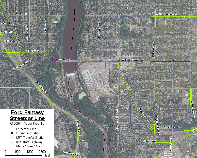
Minor point, but I'd run the portion of the line through the Ford Site such that the intersection with Ford Parkway is as far east as possible -- probably roughly in line with Cretin -- so that a station located there would provide good access to the node at Cleveland.
-
HiawathaGuy
- Wells Fargo Center
- Posts: 1636
- Joined: June 4th, 2012, 12:03 pm
Re: Riverview Corridor
Agreed, I just wanted to show the line starting at 7th and running through the current land before showing the connection on the Minneapolis side of the bridge. I've updated the map accordingly.Minor point, but I'd run the portion of the line through the Ford Site such that the intersection with Ford Parkway is as far east as possible -- probably roughly in line with Cretin -- so that a station located there would provide good access to the node at Cleveland.
-
VAStationDude
- US Bank Plaza
- Posts: 764
- Joined: June 1st, 2012, 10:30 am
Re: Riverview Corridor
Why not a single track section from Snelling and 46th, across Hiawatha and a sharp turn to a shared riverview northbound blue line platform? Seems much cheaper.
-
HiawathaGuy
- Wells Fargo Center
- Posts: 1636
- Joined: June 4th, 2012, 12:03 pm
Re: Riverview Corridor
I'm not really following you. Are you saying the Riverview line should turn north across Hiawatha? I'm not seeing how you can have a shared platform at 46th? Also, 46th & 50th are both side platforms, while the VA station has a center. So it could be a logical transfer station before the line splits (northbound) from MOA & the Airport. It's not as convenient for southbound Blue to northbound Riverview - but it's not horrible.Why not a single track section from Snelling and 46th, across Hiawatha and a sharp turn to a shared riverview northbound blue line platform? Seems much cheaper.
-
VAStationDude
- US Bank Plaza
- Posts: 764
- Joined: June 1st, 2012, 10:30 am
Re: Riverview Corridor
Yes. Turn north at 46th. The current north blue line platform would become an island platform.
Re: Riverview Corridor
HG I was looking at that routing too but Minnehaha Falls is the crown jewel of the park system and there's no way they'd approve this given that they're arguing over that little bridge at Cedar Lake.
-
RailBaronYarr
- Capella Tower
- Posts: 2625
- Joined: September 16th, 2012, 4:31 pm
Re: Riverview Corridor
I think one important thing being missed here when talking about the Ford Plant redevelopment site is the opportunity cost of not doing something rail-wise now while infrastructure is being built. If we assume the A Line + existing local/express routes are enough and cross Riverview on Fort Rd Bridge (which, is fine ultimately) we miss a huge chance to get some speedy rail through a densifying area on the cheap.
But I wholeheartedly agree on the thinking that we should view this as an opportunity to leverage infrastructure to provide future services rather than looking at it as simply a line that serves two ends and some potential points in between. There may be benefit 20+ years in the future to open the possibility of a Midtown>Blue>Riverview + MSP/MOA>DtStP both via the same river crossing, each running every 7.5 minutes (or something). But I'm not sure that's how planning these lines works.
But I wholeheartedly agree on the thinking that we should view this as an opportunity to leverage infrastructure to provide future services rather than looking at it as simply a line that serves two ends and some potential points in between. There may be benefit 20+ years in the future to open the possibility of a Midtown>Blue>Riverview + MSP/MOA>DtStP both via the same river crossing, each running every 7.5 minutes (or something). But I'm not sure that's how planning these lines works.
-
Tcmetro
- Wells Fargo Center
- Posts: 1777
- Joined: May 31st, 2012, 8:02 pm
- Location: Chicago (ex-Minneapolitan)
Re: Riverview Corridor
I like the idea of serving Highland Park and the Ford Plant site, but it seems there are many logistical issues with such a plan. First, is the fact that such a route would be quite roundabout if the intention of the line is to connect St. Paul with the Airport, Mall of America, and South Loop areas. Additionally, the River crossing and the parks make any line quite difficult to implement.
The Fort Rd crossing is also quite complicated, but perhaps not as much so. The 5/55 interchange is an awful mess and needs to be reconstructed, and on the St. Paul side of the river, Hwy 5 should be rerouted into Shepard Rd. Certainly an expansion of the footprint of the road in the Fort Snelling area is going to be quite contentious. I think that the connection into the Blue Line is quite a bit easier as well.
Perhaps the best option for the Ford Plant site is a streetcar line that connects from the 46th St Blue Line station to the Sibley Plaza neighborhood. It wouldn't be prohibitively expensive, but it could improve the attractiveness for using transit between Highland Park and Downtown Minneapolis.
-
HiawathaGuy
- Wells Fargo Center
- Posts: 1636
- Joined: June 4th, 2012, 12:03 pm
Re: Riverview Corridor
I agree Tom, but most of the land is actually owned by the state taking the route I've suggested. The only part owned by the Park Board is the part after it crosses the VA Home bridge along the Hiawatha sound wall. But you're probably right, regardless.HG I was looking at that routing too but Minnehaha Falls is the crown jewel of the park system and there's no way they'd approve this given that they're arguing over that little bridge at Cedar Lake.
All very good points.I like the idea of serving Highland Park and the Ford Plant site, but it seems there are many logistical issues with such a plan. First, is the fact that such a route would be quite roundabout if the intention of the line is to connect St. Paul with the Airport, Mall of America, and South Loop areas. Additionally, the River crossing and the parks make any line quite difficult to implement.
The Fort Rd crossing is also quite complicated, but perhaps not as much so. The 5/55 interchange is an awful mess and needs to be reconstructed, and on the St. Paul side of the river, Hwy 5 should be rerouted into Shepard Rd. Certainly an expansion of the footprint of the road in the Fort Snelling area is going to be quite contentious. I think that the connection into the Blue Line is quite a bit easier as well.
Perhaps the best option for the Ford Plant site is a streetcar line that connects from the 46th St Blue Line station to the Sibley Plaza neighborhood. It wouldn't be prohibitively expensive, but it could improve the attractiveness for using transit between Highland Park and Downtown Minneapolis.
I agree that a trip through the Ford plant site, then through Minnehaha Park adds a lot of complexity. I personally like the Fort Road bridge crossing with modifications on both sides of the river to the existing roadways. As someone who lives a block south of 50th, across from Minnehaha Park, and frequents Ford Pkwy often - I'd be all for a street car route connected 46th with West 7th in the future!
Re: Riverview Corridor
This has been my line of thinking for several years.But if there's a rail connection across the river, I can't imagine a scenario where it isn't on a modified Fort Road bridge, either above or below the road deck. It would just be too easy at that point to wye into the Blue Line near the federal building, allowing for continuation of service to the Airport and MOA. Or an easy continuation of service (as a secondary service) up to Lake Street then west across Midtown.
Using the Blue/Green connection as a rough guide, you would either need to close one direction of Hiawatha Ave or you'd have to take right-of-way on one side from 52nd to a little south of 53rd, for an at-grade crossing of 55. For a flyover, you'd need a minimum of 400ft south of 55 for the flyover approach and then additional length for the interlining, which would basically bring the right-of-way or street-closure needs all the way to 54th. The flyover approach part would also require shutting down both directions of Hiawatha south of 52nd if the goal is to minimize right-of-way acquisition.However, I have wondered how it might be possible to run the connection from the Ford Bridge through the Veteran's Home land, cross Minnehaha Creek (there's a bridge there now that would have to be reinforced or rebuilt), then turn south along the sound wall, building up to a flyover near 52nd Street & Minnehaha Ave, where the current Blue line turns and follows the center of Minnehaha. I've drawn it on the map: HERE. I still don't think there's enough space at that intersection for the width needed to interline the tracks, and ramp up to a flyover. However - this could be the one spot along Hiawatha where a line could cross at-grade relatively easily... I'm not sure how much support that would get from MnDOT or the neighborhood, but it would allow for a pretty easy connection to the Ford Bridge.
...said the George Washington Bridge engineers in the 1960s. Though to be fair, GWB was 30 years old by then and not 50."Just add another deck to the fifty year old bridge. That should be easy," said no engineer ever.
Yep...Perhaps the best option for the Ford Plant site is a streetcar line that connects from the 46th St Blue Line station to the Sibley Plaza neighborhood.
Re: Riverview Corridor
I'm as guilty of this as the next guy, but I think this thread is a great example of how the idea that somebody thinks of is the only one that makes sense to them. People will look right past the faults in their own ideas but point out every single pimple on somebody else's.
-
mattaudio
- Stone Arch Bridge
- Posts: 7759
- Joined: June 19th, 2012, 2:04 pm
- Location: NORI: NOrth of RIchfield
Re: Riverview Corridor
Isn't that why people discuss things on a message board?
Who is online
Users browsing this forum: No registered users and 146 guests