Page 4 of 16
Re: Fantasy maps
Posted: May 18th, 2016, 12:22 pm
by DanPatchToget
^^Suggestion-Extend Line 1 (Red) or Line 6 (Blue) to Southwest Station
This is not as close as it looks on his angular map. The Red and Blue (on this map) end at Mall of America. To "extend" to Southwest Station is 12 miles!!!
I know, but the extension would serve the American Blvd./I-494 Corridor which has a lot of jobs along it including the Best Buy HQ and Normandale Lake District.
Re: Fantasy maps
Posted: May 19th, 2016, 11:35 am
by mamundsen
^^Suggestion-Extend Line 1 (Red) or Line 6 (Blue) to Southwest Station
This is not as close as it looks on his angular map. The Red and Blue (on this map) end at Mall of America. To "extend" to Southwest Station is 12 miles!!!
I know, but the extension would serve the American Blvd./I-494 Corridor which has a lot of jobs along it including the Best Buy HQ and Normandale Lake District.
Sure, but that's likely a whole new line not just an extension.
Re: Fantasy maps
Posted: May 19th, 2016, 12:36 pm
by mattaudio
Sure, but that's likely a whole new line not just an extension.
Whole new line? Yes. Extension of an existing service? Yes. See SWLRT and Bottineau.
Re: Fantasy maps
Posted: May 19th, 2016, 9:04 pm
by SkyScraperKid
The light blue line should be switched to a different color.. I don't think you can call a line the "light blue line" Could use Pink or another color! idreyn
Re: Fantasy maps
Posted: May 20th, 2016, 10:42 am
by idreyn
I have to say it looks teal to me (halfway between blue and green, get it?) but I am pretty colorblind so I'll take another look. Regardless after six lines or so I think most rapid transit systems need to switch from color designations to letters/numbers (as LA is doing).
@thatchio you're right on about the cost of tunnels and a slightly more realistic proposal would probably have a single downtown N/S tunnel. The issue is that it may be hard to get good service frequencies to two northern branches — plus I'd really like to see a Hennepin subway, though I imagine it would be a relatively low-priority add to the system with the first tunnel in place.
Re: Fantasy maps
Posted: May 21st, 2016, 10:34 am
by BigIdeasGuy
The Twin Cities express, appearing as part of Green on the map, is an express service between the downtowns and would be realized as either I-94 median rail or some kind of crazy beefing up of the Central corridor (think underpasses, CBTC, and more crossovers) that would permit an express service on two tracks. This is easily the craziest proposal here but I think a frequent way to connect the two downtowns at a speed faster than car travel on I-94 is actually pretty necessary to make taking transit clear across the metro appealing and feasible, and to really knit together economic opportunities across our sprawling Cities.
I've been kicking around the idea of an express LRT service between the two downtowns in my head well for a while and there are some large challenges for sure but I think you are largely on the right track. Running down the middle of 94, to me, seems like the most efficient and effective way to get move between the downtowns.
Assuming Riverview gets built using those tracks from Union Station to the X from there it would make the most sense then veering off and running down the middle of 94 stoping at Snelling and having some sort of vertical transportation to provide access to the A-Line. From there it would need to access the U somehow and I'm still not sure what the best way to do that is (maybe using the existing railroad bridge combined with streetcar?) It could continue down the middle of 94 and meet with existing Blue Line tracks by Cedar Riverside and follow the tracks Target Field.
Re: Fantasy maps
Posted: August 26th, 2016, 1:11 pm
by mulad
Here's a post of mine from earlier in the week about a concept I put together for reactivating passenger service on much of Minnesota's rail network, along with potential lines to restore or build new to fill in some gaps. I focused on serving cities of 5,000 or more:
https://streets.mn/2016/08/23/a-broader- ... minnesota/
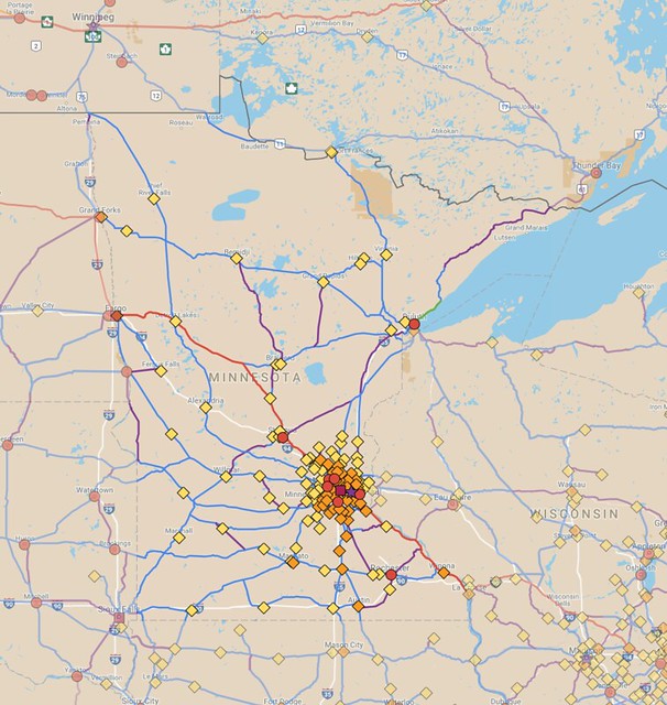 mn-combined-full-cities
 by
Michael Hicks, on Flickr
I know some of you guys had seen it and commented on it, but I figured I'd post it here too.
I've had to make a bunch of maps in the process. The image is stitched together from several maps that I've been working on:
Minnesota,
Michigan,
Wisconsin,
Iowa,
Nebraska,
South Dakota,
North Dakota,
Manitoba, and
Ontario.
While many of those are mostly complete, they're all still works in progress to varying extents. I also have maps for
Alaska,
British Columbia (& Yukon),
Alberta,
Saskatchewan,
Quebec,
Montana,
Wyoming, and
Illinois.
We'll see how much farther I manage to get. That's already a sizeable chunk of the continent, so I'll try to keep going on that, but it'd probably be a year or two to finish (if I don't just give up on it before then). I'm going to try a similar thing with some other countries too for comparison purposes (I'll probably just map existing rail and not worry about trying to add new lines to them).
I've started on a
Norway map, for example, just since they have a similar population to Minnesota (5.2 million vs. Minnesota's 5.5 million). Norway's actually less dense overall than Minnesota by a pretty wide margin (35 pp/sq.mi. vs. MN's 67 pp/sq.mi.), though obviously its cities are denser. They manage to have a ridership of 60 million annually on their intercity and commuter networks, compared to only about 800,000 or so for Amtrak + Northstar in Minnesota (they also have a bus network which carries even more people, over 100 million annually).
Re: Fantasy maps
Posted: March 18th, 2017, 8:00 pm
by Tiller
I revised my map from before, this time including Washington County, St Paul's streetcars, some transit centers, and other tweaks. (aside from being in a more appropriate thread)
Fwiw frequency on the various bus lines isn't necessarily what they are currently (ie route 80 would be more than a peak-time service). I would assume they would run at least every 30 minutes, and cover a fairly full span of the day, because service less than that wouldn't be very useful.
https://drive.google.com/open?id=1hXkDg ... sp=sharing
Re: Fantasy maps
Posted: March 19th, 2017, 11:58 am
by illman00
Here's my crappy idea since I work and plan to live in Wayzata and might be nice to have the Wayzata depot back for passenger use. So I'd have a commuter line like Northstar go from Wayzata to Minneapolis to St Paul directly, maybe a stop at West End. Also could extend west to Long Lake or Maple Plaine and have a park n ride there and then east to Woodbury or something.
Uses existing rail line and has few crossings.

Re: Fantasy maps
Posted: March 19th, 2017, 1:41 pm
by Anondson
You could arguably add a stop at Hopkins Crossroad since it is a concentration of apartments and condos of modest density.
Re: Fantasy maps
Posted: March 19th, 2017, 2:11 pm
by Vagueperson
I revised my map from before, this time including Washington County, St Paul's streetcars, some transit centers, and other tweaks. (aside from being in a more appropriate thread)
Fwiw frequency on the various bus lines isn't necessarily what they are currently (ie route 80 would be more than a peak-time service). I would assume they would run at least every 30 minutes, and cover a fairly full span of the day, because service less than that wouldn't be very useful.
https://drive.google.com/open?id=1hXkDg ... sp=sharing
How big is your assumption that Bush will be built into a street between Arcade and Forest? Land is owned by the Port Authority.
Re: Fantasy maps
Posted: March 19th, 2017, 2:31 pm
by Tiller
No idea, though a small street connection there is easier and seems more likely than St Paul building all those streetcars.
I like the idea of having the ability to provide transfers between any heavy rail service that may pass through in the future and our local transit system, thus the Bruce Vento and Oakdale transit centers.
Re: Fantasy maps
Posted: March 20th, 2017, 6:43 pm
by DanPatchToget
Bunch of maps I recently made:
I-394 Corridor-
https://www.google.com/maps/d/edit?mid= ... 00003&z=12
This would be part of the METRO system.
I-94 North Corridor-
https://www.google.com/maps/d/edit?mid= ... 99997&z=11
Would also be part of the METRO system.
American Blvd./I-494 Corridor-
https://www.google.com/maps/d/edit?mid= ... 00003&z=12
Either ABRT, BRT (dedicated and/or mixed), or LRT (an extension of the Blue Line).
I-694 Belt Line-
https://www.google.com/maps/d/edit?mid= ... 99997&z=11
Limited-stop bus route.
Route 162 (Crosstown Route)
https://www.google.com/maps/d/edit?mid= ... 00003&z=11
Limited-stop bus route.
Route 169-
https://www.google.com/maps/d/edit?mid= ... 00001&z=10
Limited-stop bus route.
For the limited-stop routes there would only be minor infrastructure upgrades (extended bus lanes, new on/off ramps, etc.). Frequency would likely be half an hour at most.
Re: Fantasy maps
Posted: April 24th, 2017, 5:35 pm
by DanPatchToget
Re: Fantasy maps
Posted: April 24th, 2017, 7:02 pm
by mattaudio
Here was my fantasy regional rail/S-bahn map from a few years back. The white lines are intercity services (Duluth to Des Moines for example) but the colors show interlining on the regional network.
https://drive.google.com/open?id=1hYVPD ... sp=sharing
Here's an unfinished version that has the Duluth-Des Moines core running via SPUD and Spine Line rather than Dan Patch (which seems far more feasible given current conditions).
https://drive.google.com/open?id=1NZxKp ... sp=sharing
And here's a way to allow trains to through-route downtown Minneapolis between St. Paul and the north (Empire Builder or Northstar extension to SPUD for example) by using a double-level transit tunnel (other level for Green and Blue LRT) and some other alignment from the NP #9 bridge to the old GN Marshall Street bridge.
https://drive.google.com/open?id=1IHFzz ... sp=sharing
Re: Fantasy maps
Posted: April 30th, 2017, 8:20 pm
by grant1simons2
Do small bike/ped bridge and trail connections count as maps?
Essentially I want to see some sort of trail that would bridge the gap between Beltrami and Marcy-Holmes that's created by Hennepin. The trail could also be used in future connections between a NE diagonal greenway, a trail that leads to the Capitol along Energy Park and possibly the Midtown Greenway if extended East. Fillmore is already pretty bikeable, and 9th Ave made sense since it will run into 8th. The rail it would be replacing is mostly abandoned, but a small bridge would need to run parallel to the current rail bridge.

Re: Fantasy maps
Posted: April 30th, 2017, 10:18 pm
by Mooglemuffins
I like it! That would be a nice addition especially in conjunction with a NE greenway.
Re: Fantasy maps
Posted: May 1st, 2017, 9:01 am
by MNdible
Wouldn't it make more sense just to connect up to 6th Ave SE, which is already a bike boulevard and extends to the Stone Arch?
Re: Fantasy maps
Posted: May 1st, 2017, 9:26 am
by grant1simons2
Of course it would. But I also wanted to make this realistic, and removing parts of a building for a bike trail is challenging.
Re: Fantasy maps
Posted: May 1st, 2017, 9:37 am
by EOst
There are already supposed to be (unfunded) plans for a bridge over Hennepin connecting 6th to the Presidents bikeway. Not easy to imagine how anything here would get funding.