The Future of CSAH 25
Posted: May 25th, 2019, 1:48 pm
I nearly added this update in the Highway 7 thread because so many of us still refer to this sliver of highway as Highway 7. But the highway stretch between TH 100 and France Ave is officially known as County Road 25.
It has a fascinating origin as part of an original plan to run a highway through Kenilworth corridor. But we have this remnant of a decades old plan taking up a tremendous amount of real estate facilitating high speed driving right onto Lake Street where they come to a crawl. Some, (including me) have posted fantasy designs for a future of the corridor. Others add this highway rump on their short list of highways that should be removed entirely. Here's my fantasy from three years ago.
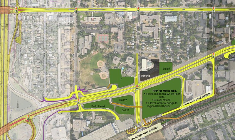 Belt Line Station Area Fantasy Map by Eric Anondson, on Flickr
 Minnetonka-Lake-France-Cty25 by Eric Anondson, on Flickr
I bring up my fantasy that I posted three years ago because...
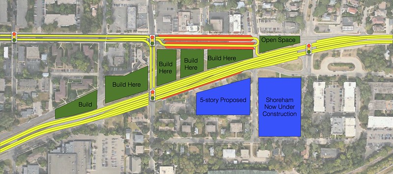
I found in the May 28 agenda for the Saint Louis Park city council (https://www.stlouispark.org/home/showdocument?id=13702) a presentation of future roadway layout that changes up a lot of the frontage road design (removing parts of it near Beltline/Ottawa), proposing a new stoplight at Raleigh, a major sidewalk expansion on the northside of the Minnetonka Blvd entrance. Quiet a few similarities! IMG_0145 by Eric Anondson, on Flickr
 IMG_0146 by Eric Anondson, on Flickr
 IMG_0147 by Eric Anondson, on Flickr
I think they still need to consider closing the norther frontage road on the west from accessing Ottawa and instead having the Raleigh stoplight accessible to the north.
I'm not impressed with the bike lane protected parking bays on the north side of Minnetonka. What should happen is instead use more of the wasteful highway median by pushing the Minnetonka entrance further south into the grassy median and swapping the bike lane with the parking.
I like that there is a thought about adding a bike trail along the south side of CSAH 25 from the Minneapolis border all the way to TH 100.
It has a fascinating origin as part of an original plan to run a highway through Kenilworth corridor. But we have this remnant of a decades old plan taking up a tremendous amount of real estate facilitating high speed driving right onto Lake Street where they come to a crawl. Some, (including me) have posted fantasy designs for a future of the corridor. Others add this highway rump on their short list of highways that should be removed entirely. Here's my fantasy from three years ago.
Belt Line Station Area Fantasy Map by Eric Anondson, on FlickrMinnetonka-Lake-France-Cty25 by Eric Anondson, on FlickrI bring up my fantasy that I posted three years ago because...
I found in the May 28 agenda for the Saint Louis Park city council (https://www.stlouispark.org/home/showdocument?id=13702) a presentation of future roadway layout that changes up a lot of the frontage road design (removing parts of it near Beltline/Ottawa), proposing a new stoplight at Raleigh, a major sidewalk expansion on the northside of the Minnetonka Blvd entrance. Quiet a few similarities!
IMG_0145 by Eric Anondson, on FlickrIMG_0146 by Eric Anondson, on FlickrIMG_0147 by Eric Anondson, on FlickrI think they still need to consider closing the norther frontage road on the west from accessing Ottawa and instead having the Raleigh stoplight accessible to the north.
I'm not impressed with the bike lane protected parking bays on the north side of Minnetonka. What should happen is instead use more of the wasteful highway median by pushing the Minnetonka entrance further south into the grassy median and swapping the bike lane with the parking.
I like that there is a thought about adding a bike trail along the south side of CSAH 25 from the Minneapolis border all the way to TH 100.