Wasn't sure where to put this.
http://www.minnpost.com/political-agend ... -bicycling
Bicycle Infrastructure
-
twincitizen
- Moderator
- Posts: 6383
- Joined: May 31st, 2012, 7:27 pm
- Location: Standish-Ericsson
Re: Bicycle Infrastructure
Another take from Strib: http://www.startribune.com/local/minnea ... 83211.html
-
PhilmerPhil
- Moderator
- Posts: 1064
- Joined: May 31st, 2012, 11:38 am
- Location: SOUP: SOuth UPtown
Re: Bicycle Infrastructure
They oughta find a better photo to use for their bike stories. I've seen this one a few times and all I see in it is biking at its worst. Road warriors in a concrete wasteland surrounded by cars doesn't really represent the fact that more and more people are finding biking as a simple, attractive, and fun way to get around town.
Re: Bicycle Infrastructure
https://skydrive.live.com/?cid=3390ba1b ... 1D01%21127
st. paul bikeways plan documents. highlights include filling in gaps in the grand round and a downtown loop
st. paul bikeways plan documents. highlights include filling in gaps in the grand round and a downtown loop
-
Minneapolisite
Re: Bicycle Infrastructure
That downtown loop is one of the stupidest plans for bike infrastructure I've seen. Seriously, could you imagine if Mpls likewise only had a square box going around but not connecting cyclists with the vast majority of destinations on Nicollet, Hennepin, and 1st? And how have all of the planners not visited Mpls when we're right next door, because there's no way they did and still came up this.
This plan still leaves Downtown isolated as far as cyclists are concerned because again you have a loop that doesn't allow you to criss-cross Downtown and also because although the loop will connect to nearby trails those don't lead to enough on-street bikeways to surrounding neighborhoods and destination rich areas where people live. This plan is definitely for recreational riders and not people needing or wanting to get from point A to B.
This plan still leaves Downtown isolated as far as cyclists are concerned because again you have a loop that doesn't allow you to criss-cross Downtown and also because although the loop will connect to nearby trails those don't lead to enough on-street bikeways to surrounding neighborhoods and destination rich areas where people live. This plan is definitely for recreational riders and not people needing or wanting to get from point A to B.
-
PhilmerPhil
- Moderator
- Posts: 1064
- Joined: May 31st, 2012, 11:38 am
- Location: SOUP: SOuth UPtown
Re: Bicycle Infrastructure
To be fair, the loop was inspired by the Indianapolis Cultural Trail, which, judging solely on that video, seems like a pretty good way to get non-cyclists to consider riding in the city a possibility. If designed properly, I see this doing well. Also, from what I know, the plan is supposed to include on street bikeways downtown in addition to the loop.
My biggest gripe with the plan is the 20-30 year timeline. What gives? What makes bike infrastructure so good is that it's cheap and often times doesn't require much more than paint, bollards, and political will.
My biggest gripe with the plan is the 20-30 year timeline. What gives? What makes bike infrastructure so good is that it's cheap and often times doesn't require much more than paint, bollards, and political will.
-
Minneapolisite
Re: Bicycle Infrastructure
I do have to agree that the timeline is the big offender here: decades to stripe lanes and connect relatively small gaps to complete St Paul's Grand Rounds? Really? Even highway, bridge, and rail projects get done a good deal faster. It really does speak to the lack of political will in St Paul. I swear if we didn't drag them kicking and screaming not only would there be no light rail in St Paul, but no bike lanes on streets like Summit and Como where Mpls created infrastructure up to St Paul.
-
mattaudio
- Stone Arch Bridge
- Posts: 7760
- Joined: June 19th, 2012, 2:04 pm
- Location: NORI: NOrth of RIchfield
Re: Bicycle Infrastructure
It's almost like they are asking to be called a suburb.
-
Minneapolisite
Re: Bicycle Infrastructure
From the studies they cite (and must not have read) you'd think the objective was to make destinations easily accessible to lots of new cyclists, but the plan is so trail-centric and therefore just about every dense concentration of destinations in St Paul is out of reach.
-
PhilmerPhil
- Moderator
- Posts: 1064
- Joined: May 31st, 2012, 11:38 am
- Location: SOUP: SOuth UPtown
Re: Bicycle Infrastructure
FINALLY (from a city email):
After being closed for over two and a half years, the Hiawatha LRT Trail between 11th Ave S and 15th Ave S will reopen to bicycle and pedestrian traffic on January 30, 2014 at 7:00 a.m. The closure was needed to complete work related to the Central Corridor/Green Line LRT project.
Please be aware that Central Corridor workers will periodically use the trail to access work zones and complete some remaining tasks. Also be aware of the new at-grade light rail crossing between 11th Ave S and 15th Ave S. When the gate arms are down, bicycle and pedestrian traffic is required to stop until the arms are raised. While the crossing is not frequently used at this time, light rail traffic will pick up in the coming months as vehicle testing and training are performed. Additional light rail safety information related to bicycles and pedestrians can be found here. The Green Line LRT is scheduled to open to the public on June 14, 2014.
Other good trail news: The east side Midtown Greenway ramp at Bryant Ave S will officially reopen in approximately one week.
Re: Bicycle Infrastructure
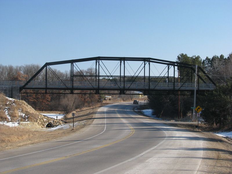
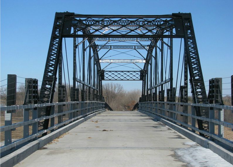
My pictures of the 1877 Silverdale Bridge; now on the Gateway Trail near Stillwater It was going to go on the Gitchi-Gammi trail, but wound up here instead for some reason. When it was on Trunk Highway 65 the daily traffic count was 35, so the one lane design wasn't a big problem. Now they need another bridge for the Brown's Creek Trail.
-
twincitizen
- Moderator
- Posts: 6383
- Joined: May 31st, 2012, 7:27 pm
- Location: Standish-Ericsson
Re: Bicycle Infrastructure
Regarding Lyndale Avenue between I-94 and Franklin: (pages 16-17 of this Bike Walk Twin Cities report about possible changes to Franklin Avenue)
Recommendations: Given the safety concerns related to southbound bicyclists attempting to travel contra-flow with northbound vehicular and bicycle traffic on the roadway and the fact that the sidewalk is too narrow to safely share, the Study Team recommends consideration of the following:
•Removal of the on-street parking spaces to facilitate in the short term a flex post protected on-road bikeway up to Franklin Avenue
•Retiming of traffic signals and striping of bicycle boxes and/or bicycle crosswalks to allow bicyclists to transition to the proper side of Lyndale and Franklin Avenue
•Long term construction of a sidewalk level, two-way cycle track between I-94 and Franklin Avenue with consideration given to extending the cycle track to 22nd St
•Development of system of wayfinding signs directing south to east bound cyclists bound for Franklin Avenue/Stevens Square/Ventura Village/Seward Neighborhoods to utilize Groveland Avenue in lieu of Lyndale to reduce bicycle volumes
Regarding the first bullet point, I'd like to see that happen in 2014. There's just no excuse. We know what the problem is and we know how to fix it. I honestly wouldn't even care if it had to be removed in the winter months, because Rudolph's wouldn't have their patio out and sidewalk bike travel is more feasible/acceptable then for this one block. Let's make this happen in summer 2014!
Re: Bicycle Infrastructure
Agreed that this should be done. I'm less certain about extending it south to 22nd, though.
-
twincitizen
- Moderator
- Posts: 6383
- Joined: May 31st, 2012, 7:27 pm
- Location: Standish-Ericsson
Re: Bicycle Infrastructure
I was dubious of that as well, but I can definitely see the desire for it from a cyclist's perspective (because I frequently ride here in the summer).
The primary need for the cycletrack extension is for people heading to businesses/homes on the east side of Lyndale Avenue or points east in Whittier. The primary need is for southbound cyclists more than northbound (riding northbound on-street is doable, but terrifying).
Riding southbound and then taking a left on EB Franklin sucks for two reasons:
a. It's uphill
b. Franklin is busy and shitty to ride on
Obviously the current state of Lyndale with the 72 curb cuts for Mortimers and Wedge Co-op is not compatible with extending the cycle track. The City really needs to engage The Wedge and be on the same page when it comes to long-term expansion/redevelopment plans.
Re: Bicycle Infrastructure
Oh, no doubt I understand why it makes sense for cyclists. Stupid topography.
But even if you were to sacrifice the on street parking in front of the Wedge, I'd fight hard against losing the pull off for the NB bus stop at Franklin.
But even if you were to sacrifice the on street parking in front of the Wedge, I'd fight hard against losing the pull off for the NB bus stop at Franklin.
-
twincitizen
- Moderator
- Posts: 6383
- Joined: May 31st, 2012, 7:27 pm
- Location: Standish-Ericsson
Re: Bicycle Infrastructure
You're absolutely right, that one should be far side, stopping in the traffic lane (with signal priority and off-board fare collection of course)


Re: Bicycle Infrastructure
Online Survey for the North Minneapolis Greenway is now open through June 15: https://www.surveymonkey.com/s/NMplsGreenway
The Project Website has more background on the current proposal and the status of the planning: http://www.minneapolismn.gov/health/liv ... isgreenway
Now is a good time to shape the proposal by participating in the survey.
The Project Website has more background on the current proposal and the status of the planning: http://www.minneapolismn.gov/health/liv ... isgreenway
Now is a good time to shape the proposal by participating in the survey.
Re: Bicycle Infrastructure
Of note a few projects in the southeast metro
1) The flood mitigation and capacity expansion bridge on what is for the time being MN 101 included a bicycle trail to Flying Cloud Drive.
2) The Bloomington Hyland Park trails are being extended southward to the Bloomington Ferry Bridge and to connect to the Eden Prairie trails.
3) A new trail along County 101 is being built to connect the Bloomington Ferry Bridge with the existing Minnesota Vally Trail.
So these three combined with the Eden Prairie trails are a significant network in the southeast, you could do a loop with only a couple of blocks from Flying Cloud Drive to the LRT trail being a gap.
Who is online
Users browsing this forum: blo442 and 40 guests