So I've been reading this book that was written in 2000 by David Anderson. It's a full history of downtown and I can't read any of it without getting really really mad at the city for screwing up what they had. Anyone who wants to check it out can, just pm me. I want to share this thing as much as I can!
Here are some picture from it
https://imgur.com/a/KoyO7#0
Downtown History
-
grant1simons2
- IDS Center
- Posts: 4369
- Joined: February 8th, 2014, 11:33 pm
- Location: Marcy-Holmes

Re: Downtown History.
preaching to the choir! if we get another happy hour going you should bring it along. some other users have done such things. do you follow old Minneapolis on Facebook they have great stuff too
-
grant1simons2
- IDS Center
- Posts: 4369
- Joined: February 8th, 2014, 11:33 pm
- Location: Marcy-Holmes
Re: Downtown History.
Follow them on Tumblr!
-
lordmoke
- Wells Fargo Center
- Posts: 1331
- Joined: June 8th, 2012, 1:39 pm
- Location: George Floyd Square
Re: Downtown History.
Just a reminder for those interested in history: Lost Twin Cities IV airs tonight on TPT 2 at 8:00.
-
lordmoke
- Wells Fargo Center
- Posts: 1331
- Joined: June 8th, 2012, 1:39 pm
- Location: George Floyd Square
Re: Downtown History
Tons and tons of great rail-related photos of Minneapolis, as well as aerial shots. There are lots of photos of Great Northern Depot and the yards surrounding it in here, extensively documenting it shortly before and during demolition.
http://www.rrpicturearchives.net/locThu ... x?id=70807
http://www.rrpicturearchives.net/locThu ... x?id=70807
-
mister.shoes

- Wells Fargo Center
- Posts: 1300
- Joined: November 26th, 2012, 10:22 am
Re: Downtown History
Thanks for the afternoon gone to waste, lordmoke  I'm really enjoying myself.
Gob-smacking: these aerials from 1972, especially those of downtown.
http://www.rrpicturearchives.net/archiv ... x?id=21980
Gob-smacking: these aerials from 1972, especially those of downtown.
http://www.rrpicturearchives.net/archiv ... x?id=21980
The problem with being an introvert online is that no one knows you're just hanging out and listening.
-
mister.shoes
- Wells Fargo Center
- Posts: 1300
- Joined: November 26th, 2012, 10:22 am
Re: Downtown History
BTW, the demolition porn really gets going around page 36/37/38.Tons and tons of great rail-related photos of Minneapolis, as well as aerial shots. There are lots of photos of Great Northern Depot and the yards surrounding it in here, extensively documenting it shortly before and during demolition.
http://www.rrpicturearchives.net/locThu ... x?id=70807
The problem with being an introvert online is that no one knows you're just hanging out and listening.
-
mister.shoes
- Wells Fargo Center
- Posts: 1300
- Joined: November 26th, 2012, 10:22 am
Re: Downtown History
And there are some phenomenal aerial shots taken from the IDS center on page 30.
The problem with being an introvert online is that no one knows you're just hanging out and listening.
-
lordmoke
- Wells Fargo Center
- Posts: 1331
- Joined: June 8th, 2012, 1:39 pm
- Location: George Floyd Square
Re: Downtown History
I had absolutely no idea which thread this would fit into best, so I'm putting it here. Slider aerial photos of midwestern downtowns showing the freeway damage.
http://iqc.ou.edu/2014/12/12/60yrsmidwest/
Too bad there's no Saint Paul.
http://iqc.ou.edu/2014/12/12/60yrsmidwest/
Too bad there's no Saint Paul.
-
twincitizen
- Moderator
- Posts: 6393
- Joined: May 31st, 2012, 7:27 pm
- Location: Standish-Ericsson
Re: Downtown History
It doesn't get much press, but the area demolished for 394 + A-Ramp was surprisingly extensive. Geographically speaking, every bit as large as the Gateway area, just far less prominent/memorable.
While the 35W/94/55 freeway tangle is regrettable, at least it spared our downtown core AND our riverfront land, something few of the other cities can claim.
Of all the cities on that list, Minneapolis might be the only one in which the present is actually an improvement (aforementioned losses aside). Unlike several of the cities on that list, we have fully revitalized and redeveloped our downtown riverfront out of former railyards and industrial land.
As much as we bemoan the intrusion of freeways into the downtown core, Minneapolis was actually quite lucky that they designed such a large downtown loop and spared the riverfront. If I had to choose between keeping the areas destroyed by freeways or keeping the Gateway largely intact, I might choose Gateway... Our freeway alignment around downtown looks like a gift compared to many, many other cities.
-
mattaudio
- Stone Arch Bridge
- Posts: 7761
- Joined: June 19th, 2012, 2:04 pm
- Location: NORI: NOrth of RIchfield
Re: Downtown History
Yep. It could be a lot worse... we could have had the Washington Ave freeway cutting off the riverfront. We could have more elevated sections than trenches. At least our trenches are fixable... 94 south of Loring and Elliot Park, and 35W near Washington seem like prime capping candidates (not that a cap needs to be large scale - just that air rights development could do a lot to create consistent frontage for the street, such as what is seen in Columbus).
You'd think we would have known better by the time in the 80s when the 394/ABC Ramp project was finalized. But we didn't.
Hopefully we can fix some of that if and when Royalston heats up and the Bob Lux blocks get developed. https://streets.mn/2014/06/12/reconnecti ... royalston/
You'd think we would have known better by the time in the 80s when the 394/ABC Ramp project was finalized. But we didn't.
Hopefully we can fix some of that if and when Royalston heats up and the Bob Lux blocks get developed. https://streets.mn/2014/06/12/reconnecti ... royalston/

Re: Downtown History
Thanks for this link. All I can say is "remarkable".I had absolutely no idea which thread this would fit into best, so I'm putting it here. Slider aerial photos of midwestern downtowns showing the freeway damage.
http://iqc.ou.edu/2014/12/12/60yrsmidwest/
Too bad there's no Saint Paul.
-
David Greene
- IDS Center
- Posts: 4615
- Joined: December 4th, 2012, 11:41 am
Re: Downtown History
Boy, you can really see how Detroit emptied out. It was decimated not so much by the freeway itself but the after-effects. And Cincinnati, WTF were you thinking on the west side of town?
-
PhilmerPhil
- Moderator
- Posts: 1064
- Joined: May 31st, 2012, 11:38 am
- Location: SOUP: SOuth UPtown
Re: Downtown History
Somewhat related, but I've been thinking about 4th Ave S lately and what kind of street it would be today if 35W didn't slice it in Whittier. North of 35W, it's lined with lots of streetcar style commercial buildings (Electric Fetus most notably), and south of 35W is the Wells Fargo office, followed by more continuous prewar commercial buildings near Lake and neighborhood nodes continuing south.
Were it not for that jog of 35W, 4th Ave probably would have been a pretty cool useful commercial corridor today, since Chicago and Nicollet are spaced pretty far apart relative to our other major corridors. However, it's probably better in the end that 35W took that route for the sake of keeping the MIA and East Whittier intact, both of which probably play big roles in making Eat Street the place that it is today.
Were it not for that jog of 35W, 4th Ave probably would have been a pretty cool useful commercial corridor today, since Chicago and Nicollet are spaced pretty far apart relative to our other major corridors. However, it's probably better in the end that 35W took that route for the sake of keeping the MIA and East Whittier intact, both of which probably play big roles in making Eat Street the place that it is today.
-
twincitizen
- Moderator
- Posts: 6393
- Joined: May 31st, 2012, 7:27 pm
- Location: Standish-Ericsson
Re: Downtown History
Let's come up with nominations for the worst decimation.
Which one of those cities got the worst freeway-related destruction?
How about the worst urban renewal / parking crater /other(non-freeway) destruction? (besides Detroit)
Which one of those cities got the worst freeway-related destruction?
How about the worst urban renewal / parking crater /other(non-freeway) destruction? (besides Detroit)
-
FISHMANPET

- IDS Center
- Posts: 4233
- Joined: June 6th, 2012, 2:19 pm
- Location: Corcoran
Re: Downtown History
Also interesting to look at rail lines. Looks like most cities, except Columbus (at least as depicted in those particular aerials), had quite a bit of waterfront rail lines, most of which have been trimmed back quite a bit now.
-
mattaudio
- Stone Arch Bridge
- Posts: 7761
- Joined: June 19th, 2012, 2:04 pm
- Location: NORI: NOrth of RIchfield
Re: Downtown History
Some of the worst decimation is that which happened to build infrastructure that wasn't even useful. I recall when I took a day trip to Rochester, NY while in Buffalo for CNU earlier this year... the entire downtown of Rochester was ringed by a freeway, most of which saw extremely low traffic volumes (under 10k IIRC) and only one corner of the loop actually mattered from a regional perspective. What a waste. Good thing some of that freeway is going away.
The best example locally is the Washington Ave trench. That destroyed a lot of grid, killed a lot of real estate, and divided neighborhoods in ways that are made even worse by the limited value it has. The worst part is that loop from Washington Ave bridge to south 35W. What a waste of an entire city block.
The best example locally is the Washington Ave trench. That destroyed a lot of grid, killed a lot of real estate, and divided neighborhoods in ways that are made even worse by the limited value it has. The worst part is that loop from Washington Ave bridge to south 35W. What a waste of an entire city block.
Re: Downtown History
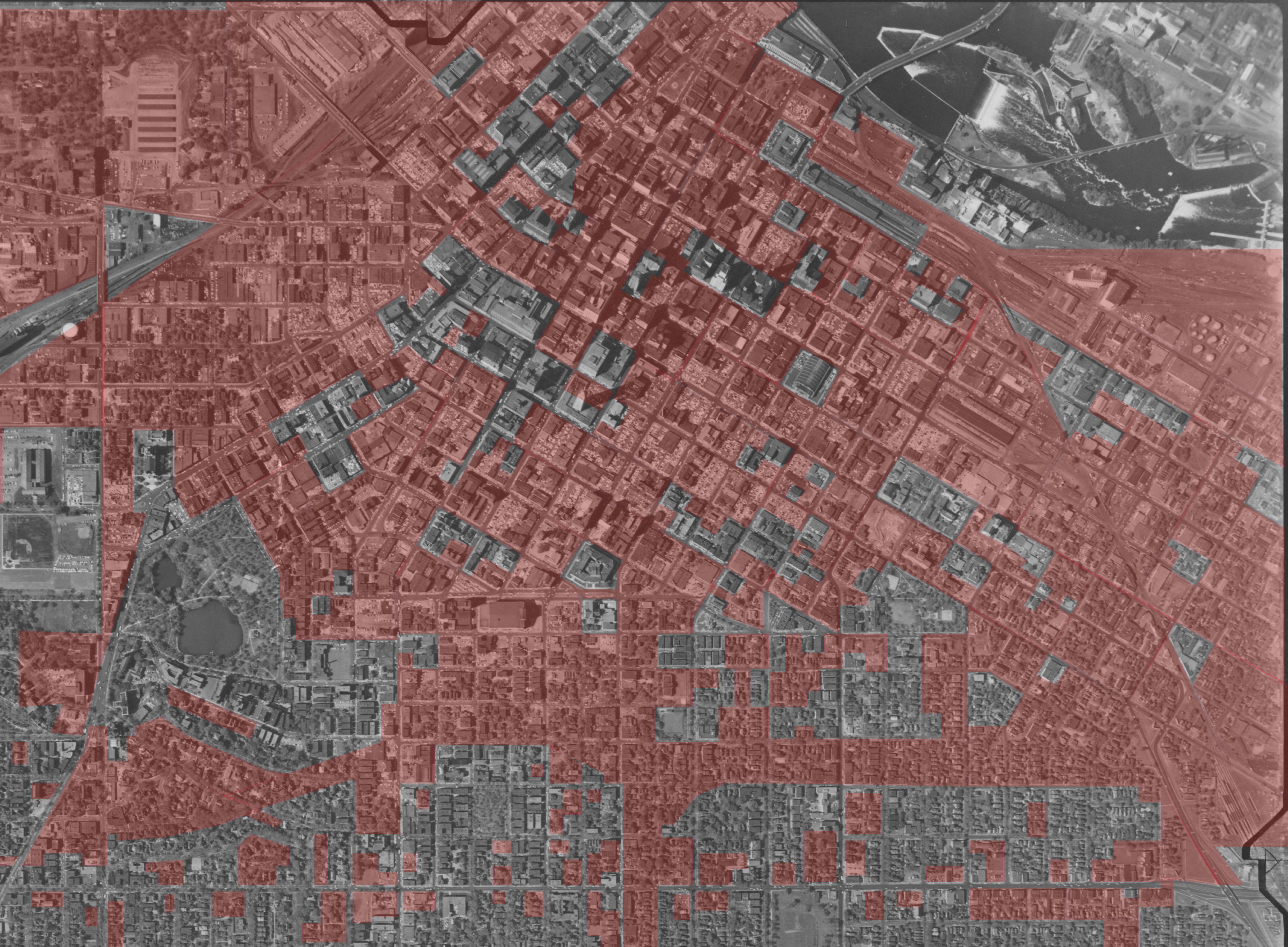
Those maps are always cool, but the fact that a lot of those lots have subsequently filled in really distorts our view of how much was lost. This is more accurate (though perhaps not entirely complete), including both intentional clearings (Gateway, south Nicollet, Convention Center, highways, etc.) and buildings/blocks of prewar buildings that were bulldozed for new construction or parking lots:
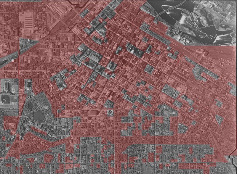
(click to enlarge)
Some of this might be off, simply because in a lot of areas, there are no buildings left to orient by.
edit: also Renaissance Square is red purely because I didn't recognize it from above
(click to enlarge)
Some of this might be off, simply because in a lot of areas, there are no buildings left to orient by.
edit: also Renaissance Square is red purely because I didn't recognize it from above
Re: Downtown History
another travesty of 94 west of the core is that the catholic archdiocese allowed the freeway to run so close to the Basilica. this would be unheard of today.
-
David Greene
- IDS Center
- Posts: 4615
- Joined: December 4th, 2012, 11:41 am
Re: Downtown History
Did they have a choice?another travesty of 94 west of the core is that the catholic archdiocese allowed the freeway to run so close to the Basilica. this would be unheard of today.
There are huge cracks in all four supporting arches surrounding the sanctuary. It's a good bet those are due to vibration. I believe there are steel arches inside so it's likely not a structural issue.
Who is online
Users browsing this forum: No registered users and 6 guests